For those about to walk, we solute you!
Posted on May 14th, 2009 – Comments Off on For those about to walk, we solute you!Walking. Is there anything better?
I’m fairly certain I’ve mentioned this before but walking around the city is the cat’s puss.
Not only do you not have to hunt down and maim ever-scarcer parking (the fight with the rival in front of the spot is the maim part), but you don’t even have to find a pole to strap your bike to. You wanna go there, you just go!
Also, it allows you to meet up with fellow walking enthusiasts like the pleasant young Brazilian ladies I played tour guide to today. No matter what angle you looked at that walking from, it looked really good. (I must apologize, I’ve been extremely negligent in my duty to carry a camera. I will try to rectify the situation post-haste.)
I probably shouldn’t go any farther with that, I blush easily. But I will say that my zeal for walking has been greatly rejuvenated. The tourists are sometimes just as, if not more, interesting than the natives. And they’re just walking around like it’s nobody’s business. Awesome!
In a way, we kind of owe much of this to map makers. Especially those who produce maps for tourists. Most of the visitors are on foot while the maps are focused on streets. Great if you’re in a car, but not very informational for someone who can travel a much wider area on foot.
A while ago I was toying with the idea of how a walking map might be different from a driving map. What kind of data should be on there that already isn’t and would also be useful to pedestrians?
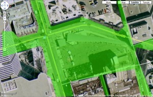
Well, for one, I thought, why not mark all areas that are accessible to pedestrians? Lots that can be walked through; breaks between buildings that are not roads (pedestrian alleys); paths through buildings that are generally open to the public (why go around when you can go through?); that kind of stuff.
Here’s an example where the green overlay demonstrates all pedestrian accessible areas.
That covers a lot more ground than a car, even though this map is actually missing a lot of detail; areas indoors and under/over the ground that you could also use to get around, for starters.
Meh. It’s Thursday.
I saw an example walking map in Spacing Wire a while ago but grading sidewalks as “pleasant” or “unpleasant” struck me as genuinely useless. I personally found some of their “unpleasant” sections extremely enjoyable. You’d think for a magazine dedicated to thinking about such stuff, they would’ve had a few good ideas.
Now, as regards the tourist population of the city, I’m not suggesting that we would ever export such maps; what I’m thinking is that we use the guides domestically to give the appearance of being extremely knowledgeable about the city. Breaking the ice could be as simple as, “Hey! Can I show you around in that alley back there!”












 Subject: Joey deVilla
 Subject: Patrick